Williams Creek Falls Trails
Very diverse and scenic trail that follows the historic Dewdney pack trail along the western edge of the Creston Valley Wildlife Management Area. The trail meanders briefly through a cedar canopy along Summit Creek before gently climbing up onto rocky arid bluffs.
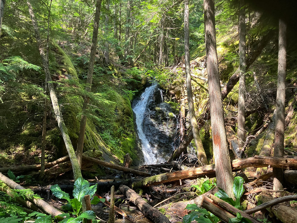
Prior to ascending the rocky bluffs an old cabin is visible. Along here you will find three (3) scenic lookouts to enjoy the views of the savanna-like wetlands & Leach Lake below. Continuing along the trail you eventually dip down into an immature cedar grove and arrive shortly at Williams Creek Falls - A small but refreshing reward for your efforts.
From Creston, travel west on Hwy 3 for 10 km to the parking area for the CVWMA just before the Summit Creek highway bridge. Starting from the Summit Creek parking lot, walk past the gate and head north along the CVWMA Access road. Trail signs provide directions to either Fern Forest Trail and Corn Creek Marsh Trail. Immediately after crossing the bridge over Summit Creek, take a left, following the signs, on an old road/path that follows along Summit Creek. Trial signs provide direction to the falls or the Wetland Bypass Trail.
Depending on the time of year the mosquito population can be abundant especially in the forested grove parts of the trail. That will set your pace. Wildflowers are in full bloom in late spring.
Family friendly, all dogs must be kept on a leash and pet owners must pick up after their pet(s).
To make this a loop you can meander your way down the creek to towards the wetlands and the option of following the dikes & roads back to Summit Creek and the parking lot.
This area is active bears area. Be sure to carry bear spray and know how to use it. Make noise on the trail, stay alert, and hike in groups when possible.
Distance
5 km return from the Summit Creek Parking lot
Difficulty
Rated Moderate - this hike offers a bit of all the best; flat open marshy areas, steep inclines, with rocks to cross, and distinct pathways to help keep on track.
Elevation
Elevation gain 113 m
Highest elevation point 640 m
Grade
1.1%
Current Conditions
Access to Leach Lake which includes the Williams Falls Trail is closed due to the high water from Summit Creek
Features
Scenic views of the wetlands and Leach Lake. The trail ends at Williams Creek Falls, a hidden gem so close to town!
Parking
Park at the Summit Creek Campground parking lot, directly off Hwy 3.
Time
Estimated time: 2 hours return, at a moderate pace. Unless you stop to enjoy all the views, then count on 3+ hours
Season
Any time of the year is a great time of the year for this one. In the winter it can be slippery on the rocky surfaces, spring can be very wet under foot through the flat spots, summer brings mosquitos, fall is very peaceful.
Dogs
Dogs are welcome, on leash. Pet owners please pick up after your pets
History of the Trail
The Williams Creek Falls Trail follows a portion of the historic Dewdney Trail, the mid-19th century pack route built by Edgar Dewdney to connect remote gold rush settlements across southern British Columbia. Winding through the western edge of the Creston Valley Wildlife Management Area, the route echoes a time when packhorses and traders moved through this landscape, forging early pathways on these lands.
Since securing access agreements with the Creston Valley Wildlife Management Area and adjacent private landowners, Trails for Creston Valley Society has stewarded the trail with volunteer-driven maintenance work and plans for educational enhancements.
Visitors today are welcomed into a trail that blends breathtaking scenery, living history, and community-led conservation—making every step a connection to Creston’s past, present, and future.