Directions
The Summit Creek trail starts from the Summit Creek parking area located on Highway 3 approximately 9.5 km west of the junction at the Ramada Inn. Walk through the gate and continue for approximately 120 meters. Take the first left onto an abandoned asphalt road, follow this to its end in a turnaround. The dirt starts after passing between two boulders and continues through an open grassed area toward Summit Creek. The trail should be visible at this point and follows Summit Creek upstream around a chain link fence, under the Highway 3 bridge and uphill to a trail junction with the Fern Forest Trail. Take the right branch (Summit Creek Trail) which continues upstream along Summit Creek.
Description
The trail parallels Summit Creek as you hike upstream through closed canopy forest and is a nice cool place to be on a hot day. A waterfall is passed on the left at about 300 meters from the trail junction, assuming the feeder creek is running. Continue gaining elevation while staying high above Summit Creek on the well-trodden trail. The main trail ends at a logging road in another 0.7 km however it is possible to continue on the undulating trail upstream past a moss-covered rock wall in another 0.6 km. The trail continues past but gets less used the further upstream you continue. In 200 meters you will encounter a small creek crossing. This is a good place to turn around unless you have more time to explore.
Elevation Profile
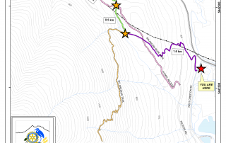
Trail Map
Quick Facts
| Distance: | 4.6km round-trip |
| Elevation Gain | 50m |
| Difficulty: | Moderate |
| Features: | Well shaded, small waterfalls |
| Time: | 2.5 hrs |
| Season: | Spring-Fall |
| Parking: | Lots |

