Trail Map
Quick Facts
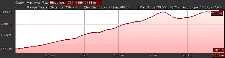
| Distance: | 6.1km Round Trip |
| Elevation Gain: | 362m |
| Difficulty: | Moderate |
| Time: | ~3 hours |
| Season: | Spring-Fall |
| Parking: | Lots |
Description
From Creston take the # 3 highway westwards to Kootenay Pass, park in the large parking lot on the right hand side where the outhouses are located. Follow a well-trodden trail above and to the left of the log building/warming shelter and continue climbing. There are several trails meandering through the forest but they all seem to merge eventually as the trail winds higher. In approximately 800 meters the trail takes a distinct left (west) bend. An avalanche control structure comes into view. Continue past this and by now the route is fairly obvious along the ridge. The trail climbs to a high point before descending along the ridge, then continues to the end of the ridge. Great views of the surrounding terrain is your reward for this relatively short hike.
Elevation Profile